Photos ? China Photos
? World Photos
? Travel Photos
? Entertainment Photos
? Sport Phtos
? Odd Photos
? Your Photos
'Danxia' scenery of Huoshizhai National Geopark, NW China
 0 Comments

Adjust font size: 

") |
|
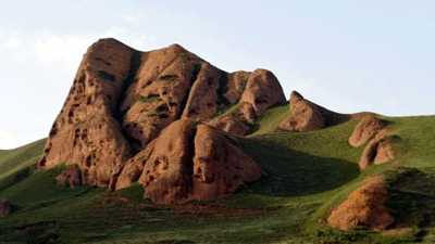
Photo taken on Aug. 14, 2009 shows craggedness of the cliffs in the Huoshizhai National Geopark in northwest China's Ningxia Hui Autonomous Region. The geopark is famous for its unique "Danxia" landform. Danxia, which means "rosy cloud", is a kind of special landform formed from reddish sandstone that has been eroded over time into a series of mountains surrounded by curvaceous cliffs and many unusual rock formations. [Xinhua/Liu Quanlong] |

Comments
No comments.


