Photos ? China Photos
? World Photos
? Travel Photos
? Entertainment Photos
? Sport Phtos
? Odd Photos
? Your Photos
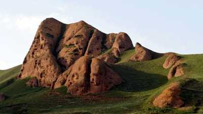
'Danxia' scenery of Huoshizhai National Geopark, NW China
 0 Comments

Adjust font size: 

") |
|
Photo taken on Aug. 14, 2009 shows a part of scenery of the Huoshizhai National Geopark in northwest China's Ningxia Hui Autonomous Region. The geopark is famous for its unique "Danxia" landform. Danxia, which means "rosy cloud", is a kind of special landform formed from reddish sandstone that has been eroded over time into a series of mountains surrounded by curvaceous cliffs and many unusual rock formations. [Xinhua/Liu Quanlong] |

Comments
No comments.


