Geographic info of Diaoyu Islands released
 0 Comment(s)
 Print
Print E-mail CNTV, September 17, 2012


The State Oceanic Administration on Saturday released a string of geographic information of Diaoyu Island and some of its affiliated islets, to reaffirm China's sovereignty. Meanwhile, the National Library of China has released a series of documents and historic books, which contain evidence the Diaoyu Islands have been Chinese territory since ancient times.
|
|
|
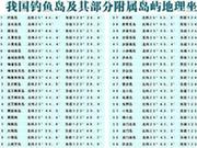
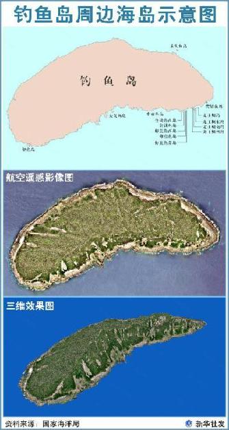
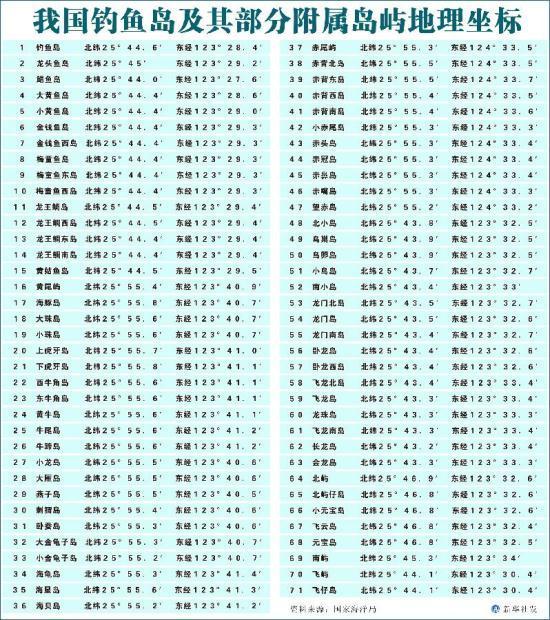
The State Oceanic Administration announcement details the exact geographic coordinates of Diaoyu Island and 70 of its affiliated islets while publishing location maps, three-dimension graphs and sketch maps for the Diaoyu Islands. |
Reaffirming China's sovereignty over the Diaoyu Islands.
The State Oceanic Administration announcement details the exact geographic coordinates of Diaoyu Island and 70 of its affiliated islets while publishing location maps, three-dimension graphs and sketch maps for the Diaoyu Islands.
The announcement aims to help the public understand information concerning Diaoyu Island and its affiliated islets.
It came after China published the base points and baselines of the islands' territorial waters on Monday.
In a separate move, more than one thousand Chinese fishing boats will sail to waters off the islands to begin fishing and the Ministry of Agriculture has asked relevant authorities to protect the fishermen's rights and safety.
Despite Japan's so called claim, historical evidence proves that Diaoyu Island and its surrounding islets have been the inherent territory of China since ancient times, and were first discovered, named and used by the Chinese.
|
|
|
The State Oceanic Administration announcement details the exact geographic coordinates of Diaoyu Island and 70 of its affiliated islets while publishing location maps, three-dimension graphs and sketch maps for the Diaoyu Islands. |
This book was written by Chen Kan(陳侃), a formal Chinese envoy to the Islands in the Ming Dynasty, in 1534. In the book, Chen describes his journey to the islands. He stated clearly he passed through the Diaoyu Islands.
Huang Ruihua, Librarian of National Library of China, said, " 'I saw the Diaoyu Islands,' said Chen Kan in his book. This sentence clearly states that China marked these places on the map as early as 1534. The Diaoyu Islands have been on the Chinese map since a long time ago. Its name has not been changed and are still used today."
The book, called "Chou hai tu bian" (籌海圖編) published in 1561, shows that the Diaoyu Islands had been placed within China's maritime defense system in the Ming Dynasty.
Li Zhizhong, Chief of Ancient Books Revision Committee, said, "Diaoyu Islands are included in our maritime defense system. There is no need to argue who owns the Diaoyu Islands. They're obviously Chinese territory."
However, books and maps published by Japan during that period shows no mention that that Diaoyu Islands are their territory.
Backed by historical evidence, the Diaoyu Islands are, beyond all doubt, Chinese territory. Japan's claim to the territory is groundless.


