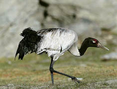
China will continue to use a satellite to track black-necked cranes wintering in southwest China's Yunnan Province, the aim being to collect ample statistics in order to protect the rare species.
According to Zhong Mingchuan, an official with the Yunnan provincial forestry department, experts will place satellite transmitters on the backs of the black-necked cranes and monitor them via satellite.
Zhong said the statistics will be used to protect the precious bird. The transmitters, which will not affect the cranes' normal life, will fall off after about two years.
China started using a satellite positioning system to protect black-necked cranes in February this year in Yunnan's Dashanbao national nature reserve. The program has proved successful.
Dashanbao reserve is the biggest wintering habitat for black-necked cranes in China. In the winter of 2004, 1,176 cranes took up residence there.
(Xinhua News Agency December 27, 2005)