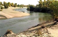
The ecosystem along the banks of the Tarim River in the Xinjiang Uygur Autonomous Region has been greatly improved as diversiform-leaved poplar trees and rose willows have become more prevalent.
Since 2000, water has been diverted several times from Bosten Lake north of the Tarim River, to the lower reaches of the waterway to rehabilitate the fragile ecosystem. So far, 1.82 billion cubic meters of water has been released into the river, said Zhu Xiangmin, director of Xinjiang Tarim River Basin Management Bureau.
The water has not only brought withered plants back to life, but has helped carry the seeds of other flora to the banks of the lower reaches, promising a more vibrant future.
"The forest of diversiform-leaved poplar trees and rose willows along the banks of the Tarim River blossomed and seeded this spring and their reproduction-ability is very obvious, now the young poplar trees and rose willows are growing along the river," said Wang Jianzhong, deputy director of the bureau.
The diversiform-leaved poplars and rose willows are well-suited to the special and dynamic conditions of the Tarim River at the edge of the Taklimakan Desert.
"It is the green corridor formed by diversiform-leaved poplar forests and rose willows along the Tarim River that prevents the Kuruktag Desert and the Taklimakan Desert from linking together," Zhu said.
"To date, a green corridor along the river with the Taklimakan Desert to the southwest and Kuruktag Desert to the northeast is being revived thanks to the water-diverting project."
Called the "mother river" by Uygurs, the Tarim River is 1,321 kilometers long, covering an area of 1.02 million square kilometers. It provides water to 9.02 million people in Xinjiang and 20.44 million mu (1.36 million hectares) of farmland.
The Tarim River is today mainly replenished by the Aksu and Hotan tributaries, and in the flood period by the Yarkant. For a long time, excessive agriculture development along the banks of the river damaged the surrounding ecological environment.
Since 1972 the lower reaches of the river, a 363-kilometre stretch beginning at the Daxihaizi Reservoir, have dried up at Taitema Lake, harming vegetation, causing serious desertification and the disappearance of many species of animals and plants.
Diversiform-leaved poplars on the banks of the main stream died because of a lack of water. About 6 million mu (400,000 hectares) in the 1950s in the upper and middle reaches of the Tarim were reduced to today's 3.6 million mu (240,000 hectares).
"Around our village, forests of diversiform-leaved poplars, shrubs, rose willows and grassland have become prevalent, and birds and animals, such as yellow goats, wild rabbits, swans and other water birds that had not been seen for 30 years have come to live here again in recent years. I am very proud of living here," said Sidike, a 103-year-old man and image-ambassador for Loboo Village, 90 kilometers away from Korla.
Loboo Village, located between the Taklimakan Desert and the Tarim River, is composed of forests of diversiform-leaved poplars, shrubs, rose willows, grasslands and many little lakes. Thanks to the improved ecosystem, local farmers have developed their village into a well-known tourist site, attracting visitors from home and abroad.
The central government launched a comprehensive ecological control program for the Tarim River in June 2001, at a cost of 10.7 billion yuan (US$1.3 billion), according to Zhu.
In order to more accurately assess the flow volume, more than 30 new supervision stations have been set up along the river.
"Once the Tarim River comprehensive management project is completed, the natural vegetation on 13,000 square kilometers of land in the Tarim River Basin will be improved, the ecological system on the lower reaches will recover, and Taitema Lake will be replenished with 350 million cubic meters of water a year," said Wang.
(China Daily September 30, 2005)