| Tools: Save | Print | E-mail | Most Read |
| Xinjiang's Ancient Milan Mapped by Satellites |
| Adjust font size: |
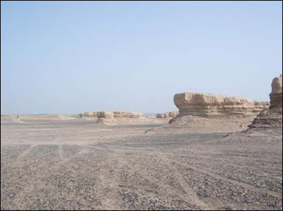
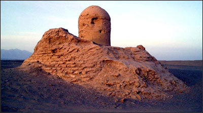
Researchers using satellite technology are drawing up maps of the ancient city of Milan in the Xinjiang Uygur Autonomous Region in a bid to better protect this important point along the Silk Road. Milan is home to many cultural relics, including the world-renowned angel murals carved some 2,000 years ago.
A team of experts from the Beijing Special Engineering Design Research Institute visited the region surveyed the ruins early this month. Using cutting-edge satellite technology, the team gathered detailed data on the over 40 square kilometre area surrounding the ruins of Milan, said Lu Hanqian, the senior engineer leading the team. "We will work with advanced GPS (global positioning system) to draw up maps of the ancient city of Milan by the end of the year. The maps will be the most accurate representations of the ruins available," the engineer said. Once the survey and maps are completed, relevant authorities will implement measures ensuring further restoring and protection on the ancient ruins, said Sheng Chunshou, director of the Xinjiang Administration Bureau of Cultural Heritage. Milan is located in the southern part of Lop Nur in Xinjiang, over 900 kilometers away from the region's capital, Urumqi. The city was an important transportation hub during the Western Han Dynasty (206 BC-24 AD), according to Yang Yiyong, a researcher at the Xinjiang Archaeology Research Institute. Yang said Milan was a major stop on the Silk Road, playing a key role in exchanges between the East and West 2,000 years ago. Milan was gradually abandoned after the Tang Dynasty (AD 618-907) due to war and worsening environmental conditions. In 1907, a British-Hungarian explorer named Aurel Stein found murals depicting winged angels in the ruins of Milan. In a book on his travels along the ancient Silk Road, he said that Milan's angels probably dated back some 2,000 years. Both Chinese and foreign archaeologists believe that the angel murals reflect a Roman influence, indicating deep cultural exchanges between China and the future countries of Europe during the Western Han Dynasty. The satellite maps of Milan represent are part of the central government's efforts to protect local cultural relics and ruins. The central government last year drew up a plan entitled "Rescue and Protection Program of the Key Relics in Xinjiang Along the Silk Road." Under this project, the government will inject 420 million yuan (US$52.5 million) in preservation projects over the next five to eight years, Sheng said. "There are 21 cultural relics, and ancient sites and ruins in Xinjiang along the ancient Silk Road listed in the protection program. We will make maps of other places to be protected in the following years," Sheng added. The ancient Silk Road starts in Xi'an, capital of the Western Han Dynasty, and ends in Rotterdam, the Netherlands. Xinjiang was an important section along this route spanning the Eurasian continent, Sheng said.
(China Daily November 23, 2006) |

| Tools: Save | Print | E-mail | Most Read |
 |
| Related Stories |