 An information system, which can demonstrate and process meteorological changes and wetland population distribution, was developed by experts with the Yangtze River Project under the World Wild Fund for Nature and the Nanjing Branch of the Chinese Academy of Sciences.
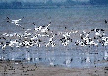
As the country’s first information system for wetland resources, the software collects data on geography, ecology, social economy and power-generating projects near the Dongting Lake, the second largest lake on the Yangtze River.
The system can use modules to imitate changes of water flow, silt formation, population distribution and township planning near the lake to help monitor the human disturbance to wildlife.
The lake area, a shelter for millions of birds and wildlife, is listed as one of the globe’s 200 most important wetland zones.
The system’s data analysis functions can provide valuable information for policy-making and forecasting of the lake reserve. The information will also be used for meteorological research on the lake, which is prone to floods.
The Chinese government is carrying out a wetland ecological recovery project in the lake area by shrinking reclaimed agricultural fields and returning them to the nature.
(Xinhua 11/16/2000)