BeiDou provides Chinese solution to the world
- By Zhang Rui
 0 Comment(s)
 Print
Print E-mail China.org.cn, May 22, 2020


Services provided by the BeiDou Navigation Satellite System (BDS) offer Chinese wisdom and accuracy to the rest of the world, according to the system's chief designer.
Yang Changfeng, who is also a member of the 13th National Committee of the Chinese People's Political Consultative Conference (CPPCC), spoke to reporters on Thursday afternoon at the Great Hall of the People in Beijing before the opening of the third plenary session of the country's top political advisory body.
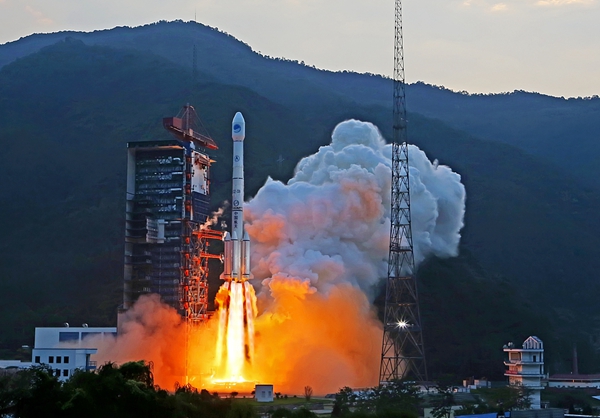
He called the global BeiDou system a "miracle" in the history of the world's satellite navigation. It took two years to form satellite networks with high-density-styled launch plans involving 17 carrier rockets and 29 satellites. "We have worked extremely hard on this system, completing it in just over 20 years, to a level where other countries took about 40 years."
China plans to complete the BDS constellation with the launch of its last satellite scheduled in June. The satellite has already arrived at the Xichang Satellite Launch Center in southwest China's Sichuan province.
The BDS's satellite-based augmentation system will provide high-precision and high-integrity services to users with meter, decimeter, and centimeter-level real-time positioning, which provides the world with "Chinese accuracy," he said. At the same time, Yang noted that they invented a hybrid constellation consisting of satellites in three different orbits, short message communication, and satellite links -- the connections among satellites and the communications between satellites and bases on earth - which all reflects Chinese wisdom.
He pointed out that although many people may not notice, about 70% of smartphones in China are compatible with BeiDou-enabled services, and over half of the world's countries are using the system. After the completion of the system scheduled in June, "the BDS will be accessible from every corner of the world and offer navigation and positioning services to everyone."
"The BDS services are widely used in various fields, including transportation, agriculture, fishing, and disaster risk reduction and relief," said Yang, stressing that the BDS has been playing an important role in COVID-19 epidemic prevention and control.
"We would love to promote international cooperation and exchange as well as multisystem compatibility, which could eventually benefit mankind and let people around the world share our achievements," the scientist said, adding they always adhere to the development concept of "Chinese BeiDou, the world's BeiDou, and the first-class BeiDou."
BeiDou is China's largest and most complicated satellite-navigation system with the highest performance requirements. It has become one of the four global networks, along with the United States' GPS, Russia's GLONASS and the European Union's Galileo. Yang believes the system has provided a Chinese solution to the world satellite navigation history.


